https://sputnikglobe.com/20231228/california-coast-put-on-alert-for-tremendous-waves-that-could-reach-up-to-40-feet-1115862951.html
California Coast Put on Alert for 'Tremendous' Waves That Could Reach Up to 40 Feet
California Coast Put on Alert for 'Tremendous' Waves That Could Reach Up to 40 Feet
Sputnik International
Pacific storms have been churning up the surf along California's coastline with monstrous waves: some as high as 40 feet (12 meters) along the Northern California coastline.
2023-12-28T22:29+0000
2023-12-28T22:29+0000
2023-12-28T22:26+0000
americas
weather
national weather service
waves
california
us
severe weather
https://cdn1.img.sputnikglobe.com/img/07e7/0c/1c/1115862652_0:160:3072:1888_1920x0_80_0_0_39589ac026fe9aef5e461c1c4c808ed2.jpg
The US state of California is preparing for massive waves this week as Pacific storms have been churning up the surf along the coastline from Eureka to Santa Cruz with monstrous waves.Waves ranging in height between 10 and 20 feet—with some as high as 25 feet—are forecasted to hit parts of central and Southern California, with officials warning peak figures for "tremendous wave energy" would likely be documented throughout Thursday. Significant beach erosion is likely as well as flooding, and some waves could even be strong enough to damage piers. High surf warnings and advisories were put into effect for the state’s coastline in preparation for the storm.Evacuations were ordered across California as the storm began. The Bay Area, Calles Pinos, Pradero, Sierra, Onda Resaca, Ribera, and parts of Calle Del Arroyo, Embarcedero all issued evacuation warnings on Thursday. “We really want to hammer home that beaches will be very dangerous,” added Nicole Sarment, a weather service meteorologist. “People should really not even go.”This is the first time that the Bay Area National Weather Service has issued a high surf warning since January, when a storm destroyed Santa Cruz’s scenic West Cliff Drive. This week, multiple storms have whipped up the Pacific Ocean over the course of several days, with a series of hurricane-force winds helping to create the threatening swell.Waves as high as 42 feet were seen in the open ocean far offshore on Wednesday, Clouser explained. “They are deadly due to their size and the potential run-up — our biggest concern is people getting too close to the water and potentially getting swept in.”
americas
Sputnik International
feedback@sputniknews.com
+74956456601
MIA „Rosiya Segodnya“
2023
Mary Manley
https://cdn1.img.sputnikglobe.com/img/07e6/01/0b/1092187887_0:0:2048:2049_100x100_80_0_0_0c2cc4c84f89aff034cc55bb01fb6697.jpg
Mary Manley
https://cdn1.img.sputnikglobe.com/img/07e6/01/0b/1092187887_0:0:2048:2049_100x100_80_0_0_0c2cc4c84f89aff034cc55bb01fb6697.jpg
News
en_EN
Sputnik International
feedback@sputniknews.com
+74956456601
MIA „Rosiya Segodnya“
Sputnik International
feedback@sputniknews.com
+74956456601
MIA „Rosiya Segodnya“
Mary Manley
https://cdn1.img.sputnikglobe.com/img/07e6/01/0b/1092187887_0:0:2048:2049_100x100_80_0_0_0c2cc4c84f89aff034cc55bb01fb6697.jpg
weather, california, coast, pacific coast, storm, waves, large waves, huge waves
weather, california, coast, pacific coast, storm, waves, large waves, huge waves
California Coast Put on Alert for 'Tremendous' Waves That Could Reach Up to 40 Feet
Waves of up to 40 feet (12 meters) high could hit California’s coastline on Thursday. The treacherous surf marks the first swell of winter weather for the Golden State.
The US state of California is preparing for massive waves this week as Pacific storms have been churning up the surf along the coastline from Eureka to Santa Cruz with monstrous waves.
Waves ranging in height between 10 and 20 feet—with some as high as 25 feet—are forecasted to hit parts of central and Southern California, with officials warning peak figures for "tremendous wave energy" would likely be documented throughout Thursday.
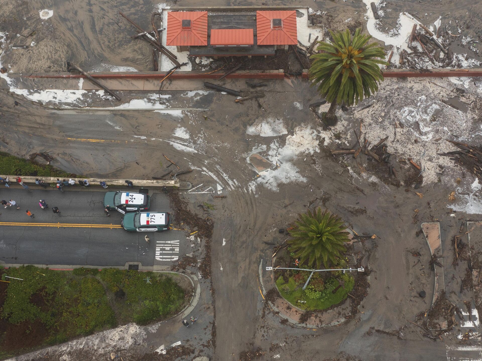
Significant beach erosion is likely as well as flooding, and some waves could even be strong enough to damage piers. High surf warnings and advisories were put into effect for the state’s coastline in preparation for the storm.
Evacuations were ordered across California as the storm began. The Bay Area, Calles Pinos, Pradero, Sierra, Onda Resaca, Ribera, and parts of Calle Del Arroyo, Embarcedero all issued evacuation warnings on Thursday.
“People are advised to stay out of and well away from the water, and keep a close eye on kids and pets,” the National Weather Service for the Bay Area wrote on Wednesday. “These are deadly conditions that can easily overpower the strongest swimmers.”
“We really want to hammer home that beaches will be very dangerous,” added Nicole Sarment, a weather service meteorologist. “People should really not even go.” This is the first time that the Bay Area National Weather Service has issued a high surf warning since January, when a storm destroyed Santa Cruz’s scenic West Cliff Drive. This week, multiple storms have whipped up the Pacific Ocean over the course of several days, with a series of hurricane-force winds helping to create the threatening swell.
At least three factors help to create these dramatic wave heights: wind speed, fetch, and time.
Fetch being the area over the ocean where winds blow and generate waves, says the weather service. The longer the weather system sits there, the higher the waves will be. These type of weather systems are also more common during the winter months.
“As those (swells) come to the coast and they break, that’s when you get those large waves at the coastlines and at the beaches,” said Alexis Clouser, a weather service meteorologist. “These are not the highest wave heights we’ve seen, but they’re certainly on the larger side."
Waves as high as 42 feet were seen in the open ocean far offshore on Wednesday, Clouser explained. “They are deadly due to their size and the potential run-up — our biggest concern is people getting too close to the water and potentially getting swept in.”


