https://sputnikglobe.com/20230906/tropical-storm-lee-likely-to-turn-into-major-hurricane-by-weeks-end-1113143538.html
Tropical Storm Lee Likely to Turn Into 'Major Hurricane' by Week's End
Tropical Storm Lee Likely to Turn Into 'Major Hurricane' by Week's End
Sputnik International
Tropical Storm Lee is headed towards the Leeward Islands and is expected to turn into a major hurricane by this weekend, but most models expect it to miss the Caribbean and United States.
2023-09-06T03:42+0000
2023-09-06T03:42+0000
2023-09-06T03:40+0000
americas
atlantic ocean
caribbean
azores
national hurricane center
florida
tropical storm
hurricane
hurricane season
https://cdn1.img.sputnikglobe.com/img/07e7/09/06/1113143641_0:130:897:635_1920x0_80_0_0_50619ef04b260d317420f5105d8199ef.png
Forecasters are predicting that the recently-formed Tropical Storm Lee is expected to rapidly accelerate into a Category 4 hurricane with wind speeds of up to 145 miles per hour (MPH), effectively turning into a major cyclone by week's end.Lee formed in the Atlantic Ocean over the week and is moving towards the Leeward Islands on the edge of the Caribbean and the Western edge of the Atlantic Ocean. According to the National Hurricane Center, Lee's current wind speed has reached up to 50 mph, an increase from 40 mph earlier Tuesday. That trend is expected to increase rapidly over the coming days until Lee becomes an “extremely dangerous” hurricane by Friday.At present, most models predict Lee will skirt just north of the Leeward islands and turn eastward before making landfall in the United States. However, the models are not 100% confident that is the case, and a few scenarios result in Lee hitting Florida and the Carolinas in 7-10 days after plowing through several Caribbean islands, while a couple scenarios predict Lee could make landfall in the Northeast region of the United States in 10 to 12 days.Where Lee ends up largely depends on the Azores High, a semi-permanent high-altitude pressure that acts as a steering wheel for storms in the Atlantic Ocean. If it remains weaker, then Lee should turn northwest before it reaches the United States, but if the Azores High strengthens over the coming days it could push Lee West, making it a danger to the Caribbean and United States.
americas
atlantic ocean
caribbean
azores
Sputnik International
feedback@sputniknews.com
+74956456601
MIA „Rosiya Segodnya“
2023
News
en_EN
Sputnik International
feedback@sputniknews.com
+74956456601
MIA „Rosiya Segodnya“
Sputnik International
feedback@sputniknews.com
+74956456601
MIA „Rosiya Segodnya“
hurricane lee, tropical storm lee, hurricanes in the atlantic, what is the next hurricane, hurricane predictions, typhoon
hurricane lee, tropical storm lee, hurricanes in the atlantic, what is the next hurricane, hurricane predictions, typhoon
Tropical Storm Lee Likely to Turn Into 'Major Hurricane' by Week's End
Lee is the 13th named storm in the Atlantic this hurricane season. To date, only four other years on record have had 13 or more named storms by September 5: 2005, 2011, 2012 and 2020.
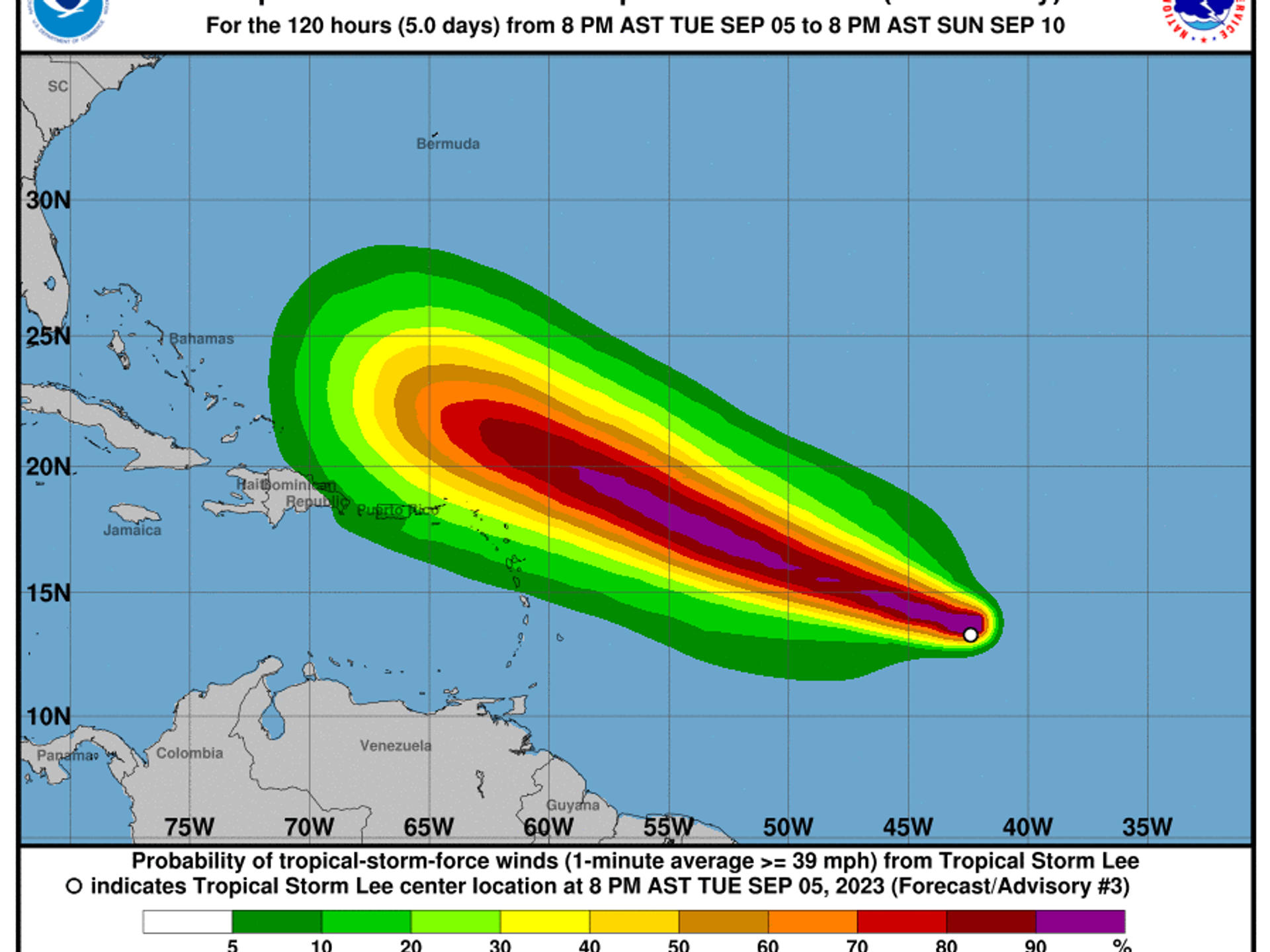
Forecasters are predicting that the recently-formed Tropical Storm Lee is expected to rapidly accelerate into a Category 4 hurricane with wind speeds of up to 145 miles per hour (MPH), effectively turning into a major cyclone by week's end.
Lee formed in the Atlantic Ocean over the week and is moving towards the Leeward Islands on the edge of the Caribbean and the Western edge of the Atlantic Ocean.
According to the National Hurricane Center, Lee's current wind speed has reached up to 50 mph, an increase from 40 mph earlier Tuesday. That trend is expected to increase rapidly over the coming days until Lee becomes an “extremely dangerous” hurricane by Friday.
At present, most models predict Lee will skirt just north of the Leeward islands and turn eastward before making landfall in the United States. However, the models are not 100% confident that is the case, and a few scenarios result in Lee hitting Florida and the Carolinas in 7-10 days after plowing through several Caribbean islands, while a couple scenarios predict Lee could make landfall in the Northeast region of the United States in 10 to 12 days.
Outliers should not be entirely discounted. In 2017, Hurricane Irma formed in the southern Atlantic Ocean and skirted along the line of the Caribbean and the Atlantic Ocean.
It was predicted to pull northwest and miss the United States, but a few outliers predicted it would make landfall in the United States and those outliers proved right. The Category 5 hurricane smashed into the Caribbean and the Southeastern US, causing over $77 billion in damage and at least 134 deaths.
Where Lee ends up largely depends on the Azores High, a semi-permanent high-altitude pressure that acts as a steering wheel for storms in the Atlantic Ocean. If it remains weaker, then Lee should turn northwest before it reaches the United States, but if the Azores High strengthens over the coming days it could push Lee West, making it a danger to the Caribbean and United States.


