https://sputnikglobe.com/20221028/india-beefs-up-military-capability-with-new-helipads-bridges-along-china-border-1102803481.html
India Beefs Up Military Capability With New Helipads, Bridges Along China Border
India Beefs Up Military Capability With New Helipads, Bridges Along China Border
Sputnik International
India and China are making efforts to out-build each other along the Line of Actual Control, a loosely demarcated boundary dividing the countries across the... 28.10.2022, Sputnik International
2022-10-28T19:09+0000
2022-10-28T19:09+0000
2022-10-28T19:09+0000
india
pla
people's liberation army (pla) navy
indian army
tibet
airbase
ladakh standoff
arunachal pradesh
rajnath singh
https://cdn1.img.sputnikglobe.com/img/07e6/06/1b/1096699816_394:0:4035:2048_1920x0_80_0_0_972c5a403607ae0105e6286be6b56f31.jpg
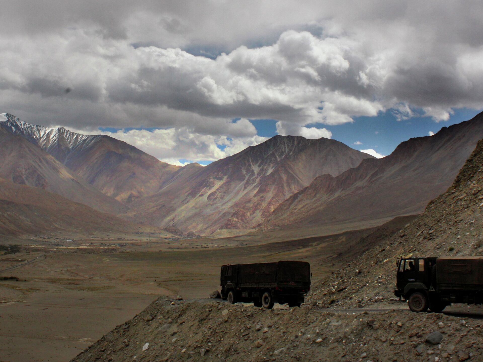
India on Friday operationalized strategic bridges, roads, and helipads to assist the armed forces in moving men and materiel rapidly in the event of a conflict with China. Among 75 infrastructure projects, the Indian Defense Ministry highlighted the inauguration of the 120-meter-long Class 70 Shyok Bridge on Darbuk-Shyok-Daulat Beg Oldi (DSDBO) road, passing through mountain passes up to the world's highest airstrip in the Ladakh region.The construction works on the DSDBO road, at an altitude of over 5,000m, were considered one of the reasons for the June 2020 clash, in which 20 Indian and four PLA troops were killed in the Galwan Valley.Other projects inaugurated virtually by Defense Minister Rajnath Singh were two helipads, one each in Hanle and Thakung in Eastern Ladakh. "These helipads will enhance the operational capabilities of the Indian Air Force in the region," the defense minister added.Out of the total 75 infrastructure projects, 20 are in Jammu and Kashmir; 18 each in Ladakh and Arunachal Pradesh; five in Uttarakhand; and 14 in other border states such as Sikkim, Himachal Pradesh, Punjab, and Rajasthan.India will also start upgradation works for its Nyoma advanced landing ground to operate fighter aircraft less than 50 kilometers from the LAC in Eastern Ladakh. The airfield is used to monitor the movements of the People’s Liberation Army from an altitude of 5,000m.The heightened threat perception of a China-Pakistan military nexus has prompted India to set up a new advanced landing ground in Parma Valley with the aim of targeting the G219 — or the Western Highway, which is considered the Chinese military's lifeline.The Western Highway connects Xinjiang in China's southwest with Tibet, after which it branches off near Quilanaldi and becomes the Karakoram Highway. This is the way through which Pakistan and China could launch a joint offensive against India.Currently, India has airfields like Fuk Che, Nyoma, and Daulat Beg Oldie in Eastern Ladakh, a flashpoint between India and China, having witnessed several clashes since 2013.China has reportedly constructed or upgraded at least 10 air bases in order to ease PLA Air Force's fighter combat operations along the border with India. India and China share around 3,488 km of border. The two countries have never agreed on the exact position of their border, which passes through rough, inhospitable terrain from Ladakh to Arunachal Pradesh.
https://sputnikglobe.com/20220826/india-to-deploy-lightweight-tanks-along-china-border-to-seek-operational-dominance-1100027109.html
tibet
ladakh standoff
arunachal pradesh
Sputnik International
feedback@sputniknews.com
+74956456601
MIA „Rosiya Segodnya“
2022
Rishikesh Kumar
https://cdn1.img.sputnikglobe.com/img/07e4/08/04/1080055820_0:0:388:389_100x100_80_0_0_40018ee210946d65d49ffba4f4c008e1.jpg
Rishikesh Kumar
https://cdn1.img.sputnikglobe.com/img/07e4/08/04/1080055820_0:0:388:389_100x100_80_0_0_40018ee210946d65d49ffba4f4c008e1.jpg
News
en_EN
Sputnik International
feedback@sputniknews.com
+74956456601
MIA „Rosiya Segodnya“
Sputnik International
feedback@sputniknews.com
+74956456601
MIA „Rosiya Segodnya“
Rishikesh Kumar
https://cdn1.img.sputnikglobe.com/img/07e4/08/04/1080055820_0:0:388:389_100x100_80_0_0_40018ee210946d65d49ffba4f4c008e1.jpg
india, pla, people's liberation army (pla) navy, indian army, tibet, airbase, ladakh standoff, arunachal pradesh, rajnath singh
india, pla, people's liberation army (pla) navy, indian army, tibet, airbase, ladakh standoff, arunachal pradesh, rajnath singh
India Beefs Up Military Capability With New Helipads, Bridges Along China Border
India and China are making efforts to out-build each other along the Line of Actual Control, a loosely demarcated boundary dividing the countries across the Himalayas. Since 2020, the militaries of the two have been on high alert amid an ongoing border stand-off.
India on Friday operationalized strategic bridges, roads, and helipads to assist the armed forces in moving men and materiel rapidly in the event of a conflict with China.
Among 75 infrastructure projects, the Indian Defense Ministry highlighted the inauguration of the 120-meter-long Class 70 Shyok Bridge on Darbuk-Shyok-Daulat Beg Oldi (DSDBO) road, passing through mountain passes up to the world's highest airstrip in the Ladakh region.
The construction works on the DSDBO road, at an altitude of over 5,000m, were considered one of the reasons for the June 2020 clash, in which 20 Indian and four PLA troops were killed in the
Galwan Valley."The bridge will be of strategic importance as it will facilitate logistics movement of the armed forces," the ministry said.
Other projects inaugurated virtually by Defense Minister Rajnath Singh were two helipads, one each in Hanle and Thakung in Eastern Ladakh.
"These helipads will enhance the operational capabilities of the
Indian Air Force in the region," the defense minister added.
Out of the total 75 infrastructure projects, 20 are in Jammu and Kashmir; 18 each in Ladakh and Arunachal Pradesh; five in Uttarakhand; and 14 in other border states such as Sikkim, Himachal Pradesh, Punjab, and Rajasthan.
India will also start upgradation works for its Nyoma advanced landing ground to operate fighter aircraft less than 50 kilometers from the LAC in Eastern Ladakh. The airfield is used to monitor the movements of the People’s Liberation Army from an altitude of 5,000m.
The heightened threat perception of a China-Pakistan military nexus has prompted India to set up a new advanced landing ground in Parma Valley with the aim of targeting the G219 — or the Western Highway, which is considered the Chinese military's lifeline.
The Western Highway connects Xinjiang in China's southwest with Tibet, after which it branches off near Quilanaldi and becomes the Karakoram Highway. This is the way through which Pakistan and China could launch a joint offensive against India.

26 August 2022, 14:46 GMT
Currently, India has airfields like Fuk Che, Nyoma, and Daulat Beg Oldie in Eastern Ladakh, a flashpoint between India and China, having witnessed several clashes since 2013.
China has reportedly constructed or upgraded at least 10 air bases in order to ease PLA Air Force's fighter combat operations along the border with India.
India and China share around 3,488 km of border. The two countries have never agreed on the exact position of their border, which passes through rough, inhospitable terrain from Ladakh to Arunachal Pradesh.


