https://sputnikglobe.com/20210809/game-changer-india-set-to-launch-eye-in-the-sky-to-monitor-borders-in-real-time-1083561307.html
'Game Changer': India Set To Launch 'Eye In The Sky' to Monitor Borders In Real Time
'Game Changer': India Set To Launch 'Eye In The Sky' to Monitor Borders In Real Time
Sputnik International
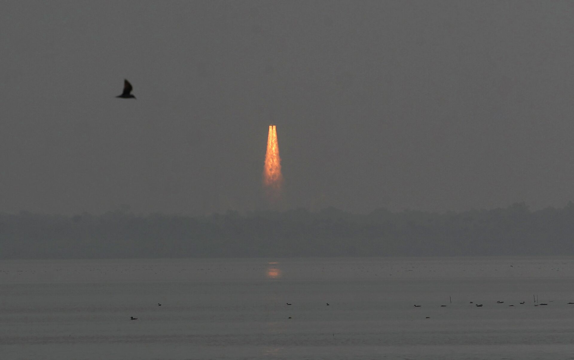
India is gearing up to place its first imaging satellite into geo-stationary orbit on 12 August. The satellite, referred to as "Eye in the Sky" by the media... 09.08.2021, Sputnik International
2021-08-09T11:14+0000
2021-08-09T11:14+0000
2022-07-19T10:38+0000
world
newsfeed
indian space research organization (isro)
defence
agriculture
sputnik
https://cdn1.img.sputnikglobe.com/img/101596/61/1015966160_0:65:2559:1511_1920x0_80_0_0_e9c093f88dc11b502392c4112f5a1e49.jpg
With deployment of troops at Indian borders at an all-time high, Indian space scientists are clearing decks to launch the country's first state-of-the-art agile Earth Observation Satellite (EOS). The launch, scheduled for 12 August from Satish Dhawan Space Centre in the state of Andhra Pradesh, will result in the Indian Space Research Organisation (ISRO) putting the satellite into an orbit high above the Earth. Geostationary orbit means that the satellite will be moving at the same circular velocity as the Earth which gives it the appearance of being fixed at one point as it floats above the Equator."India now has one of the largest constellations of remote-sensing satellites" for observing Earth and the data from these satellites will be used for "several applications covering agriculture, water resources, urban planning, rural development, mineral prospecting, environment, forestry, ocean resources and disaster management," said the ISRO.Game Changer - Real-Time Monitoring Now Possible The advanced imaging satellite has been described as a "game changer" for India with its high-resolution cameras allowing constant, real-time monitoring of the Indian landmass and the oceans. The real-time data inputs will prove critical for the defence forces engaged in securing the country's frontiers in the face of hostile incursions.The data is of greatest use to soldiers manning challenging high-altitude terrains.At present, India has about 50,000 soldiers on its borders shared with China as tensions between the two countries remain at an all-time high. Highlighting its advanced applications, the ISRO said that the satellite will also provide "spectral signatures for agriculture, forestry, mineralogy, cloud properties, snow and glaciers and oceanography".Federal Minister of the Department of Space, Jitendra Singh, answering a question in the Rajya Sabha - parliament's Upper House - said that the satellite can image the whole country four or five times a day. Launch After Several Hiccups The Gisat-1 launch has experienced severe delays thanks to technical glitches as well as the pandemic, according to the ISRO. The launch was originally meant to take place on 5 March 2020 and was cancelled for technical reasons. The launch was rescheduled for 28 March this year, but was postponed again because of a reported "minor issue", put off until April and then - as the second wave of COVID-19 broke out - delayed to the end of May.The launch is now scheduled for 12 August which is three days before India's 75th Independence Day to be celebrated on 15 August.
Sputnik International
feedback@sputniknews.com
+74956456601
MIA „Rosiya Segodnya“
2021
Priya Yadav
https://cdn1.img.sputnikglobe.com/img/07e5/02/01/1081944855_0:29:2048:2077_100x100_80_0_0_fcca548f1670eac15afebf8b8e336044.jpg
Priya Yadav
https://cdn1.img.sputnikglobe.com/img/07e5/02/01/1081944855_0:29:2048:2077_100x100_80_0_0_fcca548f1670eac15afebf8b8e336044.jpg
News
en_EN
Sputnik International
feedback@sputniknews.com
+74956456601
MIA „Rosiya Segodnya“
Sputnik International
feedback@sputniknews.com
+74956456601
MIA „Rosiya Segodnya“
Priya Yadav
https://cdn1.img.sputnikglobe.com/img/07e5/02/01/1081944855_0:29:2048:2077_100x100_80_0_0_fcca548f1670eac15afebf8b8e336044.jpg
newsfeed, indian space research organization (isro), defence, agriculture, sputnik
newsfeed, indian space research organization (isro), defence, agriculture, sputnik
'Game Changer': India Set To Launch 'Eye In The Sky' to Monitor Borders In Real Time
11:14 GMT 09.08.2021 (Updated: 10:38 GMT 19.07.2022) India is gearing up to place its first imaging satellite into geo-stationary orbit on 12 August. The satellite, referred to as "Eye in the Sky" by the media, will allow the entire subcontinent to be monitored in real time.
With deployment of troops at Indian borders at an all-time high, Indian space scientists are clearing decks to launch the country's first state-of-the-art agile Earth Observation Satellite (EOS).
The launch, scheduled for 12 August from Satish Dhawan Space Centre in the state of Andhra Pradesh, will result in the Indian Space Research Organisation (ISRO)
putting the satellite into an orbit high above the Earth.
Geostationary orbit means that the satellite will be moving at the same circular velocity as the Earth which gives it the appearance of being fixed at one point as it floats above the Equator.
"India now has one of the largest constellations of remote-sensing satellites" for observing Earth and the data from these satellites will be used for "several applications covering agriculture, water resources, urban planning, rural development, mineral prospecting, environment, forestry, ocean resources and disaster management," said the ISRO.
Game Changer - Real-Time Monitoring Now Possible
The advanced imaging satellite has been described as a "game changer" for India with its high-resolution cameras allowing constant, real-time
monitoring of the Indian landmass and the oceans.
The real-time data inputs will prove critical for the defence forces engaged in securing the country's frontiers in the face of hostile incursions.
The data is of greatest use to soldiers manning challenging high-altitude terrains.
At present, India has about 50,000 soldiers on its borders shared with China as tensions between the two countries remain at an all-time high.
Highlighting its advanced applications, the ISRO said that the satellite will also provide "spectral signatures for agriculture, forestry, mineralogy, cloud properties, snow and glaciers and oceanography".
Federal Minister of the Department of Space, Jitendra Singh, answering a question in the Rajya Sabha - parliament's Upper House - said that the satellite can image the whole country four or five times a day.
Launch After Several Hiccups
The Gisat-1
launch has experienced severe delays thanks to technical glitches as well as the pandemic, according to the ISRO. The launch was originally meant to take place on 5 March 2020 and was cancelled for technical reasons.
The launch was rescheduled for 28 March this year, but was postponed again because of a reported "minor issue", put off until April and then - as the second wave of COVID-19 broke out - delayed to the end of May.
The launch is now scheduled for 12 August which is three days before India's 75th Independence Day to be celebrated on 15 August.


