https://sputnikglobe.com/20220928/hurricane-ian-makes-landfall-in-florida-as-extremely-dangerous-category-4-storm---nhc-1101321500.html
Videos: Over 2 Million Lose Power After 'Extremely Dangerous' Hurricane Ian Makes Florida Landfall
Videos: Over 2 Million Lose Power After 'Extremely Dangerous' Hurricane Ian Makes Florida Landfall
Sputnik International
The hurricane initially made landfall in Cuba, where it tore through the island's west coast as a major storm. Forcing tens of thousands to evacuate to... 28.09.2022, Sputnik International
2022-09-28T19:15+0000
2022-09-28T19:15+0000
2022-09-29T03:36+0000
americas
us
florida
hurricane
landfall
https://cdn1.img.sputnikglobe.com/img/07e6/09/1c/1101322125_0:0:2880:1620_1920x0_80_0_0_9f964f66ab5b47756a73de8aabdee1d4.png
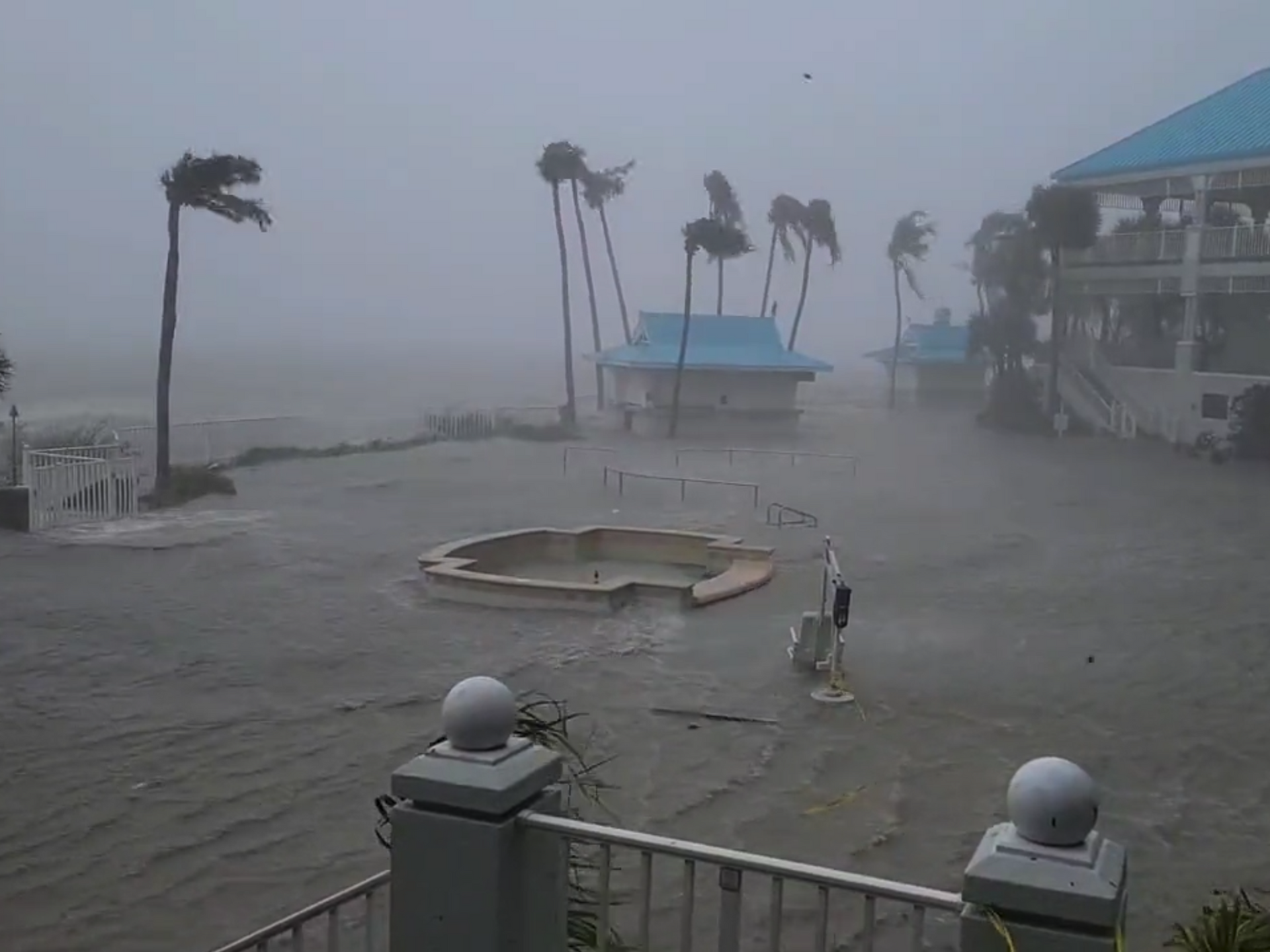
Hurricane Ian made landfall as a Category 4 storm just after 3 p.m. on Wednesday, with winds topping 155 miles per hour, the US National Hurricane Center has confirmed. “Radar imagery indicates that the eye of Ian made landfall along the southwestern coast of Florida near Cayo Costa around 305 PM EDT," reads the latest advisory issued by the hurricane agency. "Data from an Air Force Reserve reconnaissance aircraft indicate that Ian's maximum sustained winds were estimated to be near 150 mph (240 km/h).”The bulletin further detailed that the cyclone is moving in a north-northeast direction at a pace of 15 mph. The eye of the storm is sitting about 20 miles from Fort Myers, Florida, which has already seen strong winds and heavy storm surges.Forecasters say to expect “extremely dangerous” rains and winds in the next several hours along the coast of Florida as what’s being described as “one of the most powerful storms to strike the United States in decades” shifts from Cayo Costa, a barrier island off the state’s west coast, and pushes on land.An earlier NHC advisory noted that Ian was forecast to weaken after making landfall but that it would maintain hurricane-grade strength as it moved across the Sunshine State; in fact, the slow-moving cyclone was later downgraded to a Category 1 storm but remains a threat to the state due to its storm surge, winds and flooding.Parts of Florida are expected to see anywhere between six to 18 inches of rainfall, and storm surges of up to 18 inches. Coastal homes are at risk of being “swallowed” by the storm.According to data tracked by poweroutage.us, over 2 million customers in Florida are without electricity. This number is expected to increase as the hurricane continues to pass through southern Florida.Florida Power and Light Co (FPL), owned by parent company NextEra, is bearing the brunt of the outages so far. FPL has mobilized over 13,000 employees to support power restoration efforts.Though millions have been given evacuation orders, Gov. Ron DeSantis warned at a Wednesday briefing that it was “too late” for people to leave in Lee, Sarasota, Collier, and Charlotte counties, where Ian’s ire is strongest.DeSantis alerted residents in central and northeastern areas of Florida that those regions would also see the impact of the storm, which is expected to exit the state off Daytona Beach on Thursday.According to an announcement by the National Hurricane Service midday on Wednesday, heavy rainfall will spread over Florida through Thursday, bringing “widespread, life-threatening, and catastrophic flooding” and will reach other southeastern states, like Georgia and South Carolina, as we move into the weekend.
americas
florida
Sputnik International
feedback@sputniknews.com
+74956456601
MIA „Rosiya Segodnya“
2022
News
en_EN
Sputnik International
feedback@sputniknews.com
+74956456601
MIA „Rosiya Segodnya“
Sputnik International
feedback@sputniknews.com
+74956456601
MIA „Rosiya Segodnya“
us, florida, hurricane, landfall
us, florida, hurricane, landfall
Videos: Over 2 Million Lose Power After 'Extremely Dangerous' Hurricane Ian Makes Florida Landfall
19:15 GMT 28.09.2022 (Updated: 03:36 GMT 29.09.2022) The hurricane initially made landfall in Cuba, where it tore through the island's west coast as a major storm. Forcing tens of thousands to evacuate to shelters, the storm also left residents without electricity after Ian knocked out Cuba's power grid.
Hurricane Ian made landfall as a Category 4 storm just after 3 p.m. on Wednesday, with winds topping 155 miles per hour, the US National Hurricane Center has
confirmed.
“Radar imagery indicates that the eye of Ian made landfall along the southwestern coast of Florida near Cayo Costa around 305 PM EDT," reads the latest advisory issued by the hurricane agency. "Data from an Air Force Reserve reconnaissance aircraft indicate that Ian's maximum sustained winds were estimated to be near 150 mph (240 km/h).”
The bulletin further detailed that the cyclone is moving in a north-northeast direction at a pace of 15 mph. The eye of the storm is sitting about 20 miles from Fort Myers, Florida, which has already seen strong winds and heavy storm surges.
Forecasters say to expect “extremely dangerous” rains and winds in the next several hours along the coast of Florida as what’s being described as “one of the most powerful storms to strike the United States in decades” shifts from Cayo Costa, a barrier island off the state’s west coast, and pushes on land.
An earlier NHC advisory noted that Ian was forecast to weaken after making landfall but that it would maintain hurricane-grade strength as it moved across the Sunshine State; in fact, the slow-moving cyclone was later downgraded to a Category 1 storm but remains a threat to the state due to its storm surge, winds and flooding.
Parts of Florida are expected to see anywhere between six to 18 inches of rainfall, and storm surges of up to 18 inches. Coastal homes are at risk of being “swallowed” by the storm.
"This is a wind storm and a surge storm and a flood storm, all in one," CNN meteorologist Chad Myers said. "And this is going to spread itself out across the entire state. Everybody is going to see something from this."
According to data tracked by
poweroutage.us, over 2 million customers in Florida are without electricity.
This number is expected to increase as the hurricane continues to pass through southern Florida.Florida Power and Light Co (FPL), owned by parent company NextEra, is bearing the brunt of the outages so far. FPL has mobilized over 13,000 employees to support power restoration efforts.
Though millions have been given evacuation orders, Gov. Ron DeSantis warned at a Wednesday briefing that it was “too late” for people to leave in Lee, Sarasota, Collier, and Charlotte counties, where Ian’s ire is strongest.
DeSantis alerted residents in central and northeastern areas of Florida that those regions would also see the impact of the storm, which is expected to exit the state off Daytona Beach on Thursday.
According to an announcement by the National Hurricane Service
midday on Wednesday, heavy rainfall will spread over Florida through Thursday, bringing “widespread, life-threatening, and catastrophic flooding” and will reach other southeastern states, like Georgia and South Carolina, as we move into the weekend.


