https://sputnikglobe.com/20220621/threat-of-quakes-volcanoes-can-be-predicted-with-new-tectonic-plates-model-study-claims-1096523297.html
Threat of Quakes, Volcanoes Can Be Predicted With New Tectonic Plates Model, Study Claims
Threat of Quakes, Volcanoes Can Be Predicted With New Tectonic Plates Model, Study Claims
Sputnik International
By the time the Earth was about 4.2 billion years old, all the land on the planet had coalesced into one massive supercontinent called Pangaea. In the... 21.06.2022, Sputnik International
2022-06-21T12:40+0000
2022-06-21T12:40+0000
2022-11-03T19:33+0000
tectonic shift
earthquakes
university of adelaide
earth
https://cdn1.img.sputnikglobe.com/img/07e6/06/15/1096519870_0:37:1908:1110_1920x0_80_0_0_7d52666db36eda05a2803a6a3cb3271a.jpg
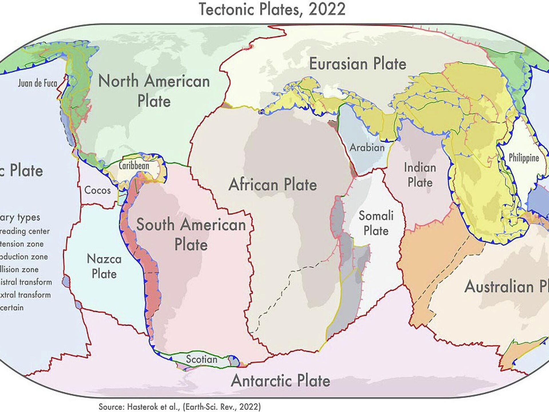
A team of scientists have developed an updated model of Earth’s tectonic plates, offering insight into how the supercontinents were assembled 2.8 million years ago.Supercontinents such as Pangaea, Gondwana, and Laurasia were vast land masses in Earth’s early history thought to have split and eventually form the continents as we know them at present. The latter, according to scientists, “drifted” about on tectonic plates - pieces of Earth's crust and uppermost mantle, collectively referred to as the lithosphere.The fresh findings into our planet’s geological history, laid out by researchers from the University of Adelaide in the monthly peer-reviewed scientific journal Earth-Science Reviews, have been welcomed as invaluable in better understanding various natural hazards.The team produced three new geological models: a plate model, a province model, and an orogeny (mountain formation) model. Such studies typically make use of geologic record, radioactive dating, seismic surveys, and other technologies to construct maps of how the world looked at various points in Earth’s history.The new model, according to the scientists, includes fresh microplates such as the Macquarie microplate, located south of Tasmania, and the Capricorn microplate, that separates the Indian and Australian plates.Tectonic plates are composed of Earth's crust and the uppermost portion of the mantle, with earthquakes typically occurring at the boundaries of the plates. This happens when one plate dips below another to thrust it upward.The Australian team had added more precise information concerning the boundaries of deformation zones. Previously, models had shown these as ‘discrete areas’ rather than ‘wide zones'.“The biggest changes to the plate model have been in western North America, which often has the boundary with the Pacific Plate drawn as the San Andreas and Queen Charlotte faults. But the newly delineated boundary is much wider, approximately 1500km, than the previously drawn narrow zone,” Dr Hasterok explained. He added that the study revealed that another large change had taken place in central Asia.Hailing the new model as now including "all of the deformation zones north of India”, scientists claimed it could be instrumental in improving prediction of earthquakes and volcanic eruptions, as well as better prospecting for minerals.
https://sputnikglobe.com/20220331/giant-mobile-blobs-lurking-inside-earth-can-be-tracked-to-find-minerals-diamonds-claims-study-1094356946.html
earth
Sputnik International
feedback@sputniknews.com
+74956456601
MIA „Rosiya Segodnya“
2022
News
en_EN
Sputnik International
feedback@sputniknews.com
+74956456601
MIA „Rosiya Segodnya“
Sputnik International
feedback@sputniknews.com
+74956456601
MIA „Rosiya Segodnya“
tectonic shift, earthquakes, university of adelaide, earth
tectonic shift, earthquakes, university of adelaide, earth
Threat of Quakes, Volcanoes Can Be Predicted With New Tectonic Plates Model, Study Claims
12:40 GMT 21.06.2022 (Updated: 19:33 GMT 03.11.2022) By the time the Earth was about 4.2 billion years old, all the land on the planet had coalesced into one massive supercontinent called Pangaea. In the approximately 300 million years since, several supercontinents have formed and broken up, driven by movement in Earth's mantle.
A team of scientists have developed an
updated model of Earth’s tectonic plates, offering insight into how the supercontinents were assembled 2.8 million years ago.
Supercontinents such as Pangaea, Gondwana, and Laurasia were vast land masses in Earth’s early history thought to have split and eventually form the continents as we know them at present. The latter, according to scientists, “drifted” about on tectonic plates - pieces of Earth's crust and uppermost mantle, collectively referred to as the lithosphere.
The fresh
findings into our planet’s geological history, laid out by researchers from the University of Adelaide in the monthly peer-reviewed scientific journal Earth-Science Reviews, have been welcomed as invaluable in better understanding various natural hazards.
“Our new model for tectonic plates better explains the spatial distribution of 90 percent of earthquakes and 80 percent of volcanoes from the past two million years, whereas existing models only capture 65 percent of earthquakes,” said Derrick Hasterok, a lecturer with the Department of Earth Sciences at the University of Adelaide.
The team produced three new geological models: a plate model, a province model, and an orogeny (mountain formation) model. Such studies typically make use of geologic record, radioactive dating, seismic surveys, and other technologies to construct maps of how the world looked at various points in Earth’s history.
“We looked at the current knowledge of the configuration of plate boundary zones and the past construction of the continental crust,” said Hasterok, who led the team.
The new model, according to the scientists, includes fresh microplates such as the Macquarie microplate, located south of Tasmania, and the Capricorn microplate, that separates the Indian and Australian plates.
Tectonic plates are composed of Earth's crust and the uppermost portion of the mantle, with earthquakes typically occurring at the boundaries of the plates. This happens when one plate dips below another to thrust it upward.
“These new plate models show improved correlation to observed earthquake and volcano occurrences within deformation zones and microplates, compared with existing models, capturing 73 and 80 percent of these criteria, respectively,” the study said.
The Australian team had added more precise information concerning the boundaries of deformation zones. Previously, models had shown these as ‘discrete areas’ rather than ‘wide zones'.
“The biggest changes to the plate model have been in western North America, which often has the boundary with the Pacific Plate drawn as the San Andreas and Queen Charlotte faults. But the newly delineated boundary is much wider, approximately 1500km, than the previously drawn narrow zone,” Dr Hasterok explained. He added that the study revealed that another large change had taken place in central Asia.
Hailing the new model as now including "all of the deformation zones north of India”, scientists claimed it could be instrumental in improving prediction of earthquakes and
volcanic eruptions, as well as better
prospecting for minerals.


